
Project Detail
Warning: Trying to access array offset on false in /home/hagorbuk/ge-hydro.work/wp-content/plugins/wp-google-map-gold/modules/shortcode/views/put-wpgmp.php on line 1799
HEC-RAS Analysis
- Location: Geneva, Switzerland
- River Reach: L’Aire
- Period of Analysis: January–March 2014
- Enterprise: SECOE, Geneva
Introduction
Flooding occurs when flowing water exceeds its bank-full stage, inundating adjacent areas. This can result from intense rainfall or significant snowmelt. In addition to inundation, increased flow velocity can erode fragile riverbanks, leading to severe damage. To mitigate these risks, protective measures along vulnerable banks should be implemented before extreme flow events occur.
River Aire: Current Stabilization Measures
Along the River Aire, several stabilization measures have been established:
- Biological or organic protection: Used to prevent further degradation of the banks.
- Gabion structures: Installed in certain areas for added stability.
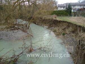
However, despite these measures, there are still sections requiring stabilization. For instance, as shown in Figures 5 and 6, riverbank curvatures are particularly prone to erosion and require additional protective measures.
Proposed Solutions:
- Construction of levees.
- Creation of temporary or provisional flood storage basins.
- Elevating villages above the flood line to prevent future flood-related damages.
HEC-RAS Model Application
The HEC-RAS model was utilized to evaluate the impact of varying discharge events. This analysis considered discharges for recurrence intervals of 10 years (Q10), 30 years (Q30), 100 years (Q100), and 300 years (Q300). The findings of the analysis provide insights into potential risks and inform recommendations for flood mitigation strategies.
The River Aire
The River Aire originates near the villages of Présilly, Beaumont, and Feigères in France. Its tributaries converge at St. Julien en Genevois before flowing toward Geneva, passing through areas such as Confignon and Lancy. Ultimately, the River Aire joins the River Arve beneath the Saint-Georges Bridge in Geneva.
Figures 1, 2, and 3 illustrate the origins and course of the River Aire.
This analysis highlights the need for proactive measures to mitigate flood risks and protect the surrounding areas from potential future damages.
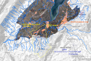
Figure 1 Catchment and watercourse of L’Aire
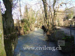
Figure 2 The river reach (5.36km)
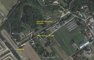
Figure 3 Newly constructed diversion structure and the diversion tunnel
Figures 4, 5, and 6 illustrate the representation of riverbanks along the specified reach.
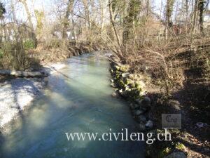
Figure 4 Vegetation covers around 2.8 km of the Pont-Rouge, Photo taken on 4.03.2014
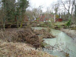
Figure 5 Eroded bank at around 4km upstream of the D/S end (photo taken on 4.03.2014)
Figure 6 Unstable bank at around 4km of the D/S end (Photo taken on 4.03.2014)
Data
Cross-sectional and hydrological data were provided to execute the HEC-RAS model. However, the source of this data was not specified, leaving it unclear whether it was obtained through field surveys, ArcGIS extractions, or other software products. Some cross-sections required modifications, and necessary corrections were made to ensure the model ran successfully.
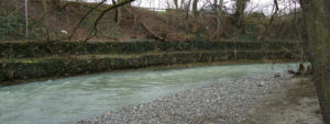
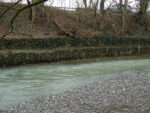
The total length of the river reach analyzed was 5363.91 meters, with an average distance of 23.5 meters between cross-sections. Along this reach, there are five bridges. The central waterway predominantly consists of cobbles and approximately 70% of the left and right banks are covered with vegetation, as depicted in Figures 7 and 8.
Based on these characteristics, the Manning’s roughness coefficient was assumed to be:
- 0.05 for the riverbed.
- 0.10 for the vegetated banks.
Additionally, lateral concrete structures and tributaries were present along the stream. The flow varied along the river, with supplementary lateral inflows observed approximately 1690 meters downstream.
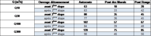
The discharge values for the four recurrence periods (Q10, Q30, Q100, Q300) are summarized in Table 1.
Table 1: Flow Measured for Four Recurrence Periods
Figures 7 and 8 illustrate the representation of the riverbed, as well as the right and left banks of the river.
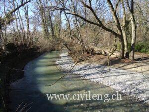
Figure 7 Cobbles along the main riverbed
Figure 8 Bank vegetation cover of the river (represent 60-70%)
The process of running the model using the data described above is demonstrated step-by-step in the following video: video link
The Result
The following Figures 9, 10, 11 show the result of the analysis in images.
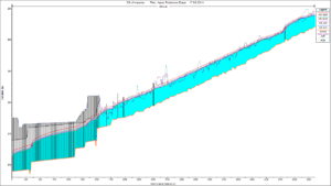
Figure 9 Longitudinal profile of the river for each return period
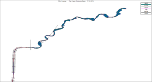
Figure 10 Plan view
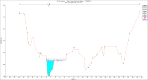
Figure 11 Cross-section at station 4107.7m
The following video link shows how to prepare HEC-RAS data using ArcGIS. Flood mapping analysis using HEC-RAS is also shown in this video link., Video link of the reach considered for this analysis
Other useful videos can also be accessed at this link